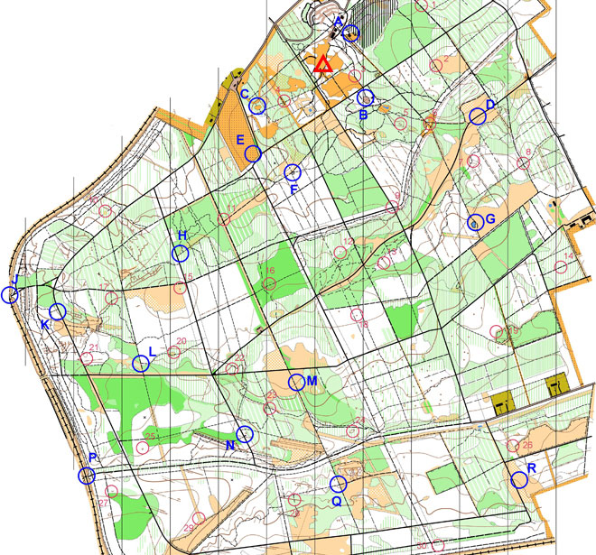
This table shows how many teams made it to each of the activity bases and other controls.
Base |
Description | Points |
Number of visits |
|---|---|---|---|
| A | Band Hero (Classroom near Go Ape.) | 50 | 23 |
| B | On the Ropes (Playground South of forest road.) | 50 | 45 |
| C | Delve of Doom (Small clearing.) | 50 | 50 |
| D | Virtual Caving (Open ground beside forest road.) | 50 | 40 |
| E | Mega Assault (Field Corner.) | 50 | 49 |
| F | Attached! (Small shelter in woods.) | 50 | 57 |
| G | Terror Island (Area around pond.) | 50 | 36 |
| H | Rollercoaster (Mixed woodland by forest road.) | 50 | 58 |
| J | The Climb (Disused railway bridge.) | 50 | 43 |
| K | Blood, Sweat & Gears (Mixed woodland by forest road.) | 50 | 54 |
| L | Totally Guttered (Woodland/open ground beside forest track.) | 50 | 16 |
| M | Giant Logic (Rough ground East of forest track.) | 50 | 51 |
| N | Quack Castle (Beside forest road.) | 50 | 44 |
| P | Black Box (Disused railway bridge.) | 50 | 24 |
| Q | Strings Attached (By path junction.) | 50 | 35 |
| R | Flying Saucers (Open ground East of forest road.) | 50 | 26 |
N.B. There was no base I to avoid confusion with number 1 or base O to avoid confusion with letter D.
| Control | Description | Points |
Number of visits |
|---|---|---|---|
| 01 | Vehicle track - East side. | 10 | 1 |
| 02 | Path crossing. | 10 | 3 |
| 03 | Top of spiders' web. | 5 | 27 |
| 04 | Path crossing. | 5 | 35 |
| 05 | Small hill (knoll). | 10 | 7 |
| 06 | South of small pond. | 5 | 36 |
| 07 | On slope among trees. | 10 | 4 |
| 08 | Path junction. | 15 | 16 |
| 09 | Road / path junction. | 10 | 21 |
| 10 | Clearing. | 20 | 1 |
| 11 | Vegetation boundary. | 10 | 51 |
| 12 | Small dip in ground (depression). | 15 | 3 |
| 13 | Gully. | 15 | 3 |
| 14 | North of footpath. | 20 | 7 |
| 15 | Small hill (knoll) - South-West side. | 10 | 35 |
| 16 | Large dip in ground (depression). | 15 | 4 |
| 17 | Gully crossing. | 20 | 12 |
| 18 | Small hill (knoll). | 20 | 10 |
| 19 | Fence corner. | 20 | 13 |
| 20 | Small forest clearing. | 20 | 11 |
| 21 | By earthwall. | 15 | 10 |
| 22 | Small valley. | 15 | 13 |
| 23 | Alongside footpath. | 20 | 13 |
| 24 | Dip in ground (depression). | 20 | 1 |
| 25 | Small pit. | 25 | 2 |
| 26 | Fence corner. | 25 | 14 |
| 27 | Small dip in ground (depression). | 30 | 4 |
| 28 | Beside small path. | 25 | 14 |
| 29 | Against fence. | 30 | 3 |
| 30 | Under pylon. | 30 | 14 |
| X1 | Chaser1 | -25 | 7 |
| X2 | Chaser2 | -25 | 1 |
| X3 | Chaser3 | -25 | 6 |
| X4 | Chaser4 | -25 | 4 |
Map © Nottinghamshire Orienteering Club and reproduced with their permission. Survey: D & P Olivant September 2008 to February 2009. Cartography: D Olivant September 2008 to February 2009. Based on the Ordnance Survey mapping with the permission of the Controller of Her Majesty’s Stationery Office. © Crown Copyright. Licence No. 43423U. BOF Registration No. EM-08-456.