
| Start time | End time | Duration | Distance | Average speed |
|---|---|---|---|---|
| 20:03:08 | 01:59:43 | 05:56:35 | 11.82 km | 1.99 km/h |
You collected points by completing 13 of the main activity bases including Delve of Doom. You returned within the six hours allowed, so avoided getting any time penalties. You managed to evade capture by the Apex Chasers which would have cost you 25 points for each time caught.
| Control | Description | Time | Points |
|---|---|---|---|
| 04 | Path crossing. | 20:06:21 | 5 |
| C | Delve of Doom (Small clearing.) | 20:17:07 | 50 |
| E | Mega Assault (Field Corner.) | 20:30:52 | 50 |
| F | Attached! (Small shelter in woods.) | 20:44:57 | 50 |
| 11 | Vegetation boundary. | 20:50:18 | 10 |
| H | Rollercoaster (Mixed woodland by forest road.) | 20:56:50 | 50 |
| 15 | Small hill (knoll) - South-West side. | 20:59:07 | 10 |
| 17 | Gully crossing. | 21:02:57 | 20 |
| 10 | Clearing. | 21:10:21 | 20 |
| J | The Climb (Disused railway bridge.) | 21:30:38 | 50 |
| K | Blood, Sweat & Gears (Mixed woodland by forest road.) | 21:45:20 | 50 |
| P | Black Box (Disused railway bridge.) | 22:42:33 | 50 |
| 27 | Small dip in ground (depression). | 22:50:32 | 30 |
| 29 | Against fence. | 23:17:54 | 30 |
| 28 | Beside small path. | 23:32:14 | 25 |
| 30 | Under pylon. | 23:41:47 | 30 |
| R | Flying Saucers (Open ground East of forest road.) | 23:56:40 | 50 |
| 26 | Fence corner. | 00:00:22 | 25 |
| N | Quack Castle (Beside forest road.) | 00:31:02 | 50 |
| 22 | Small valley. | 00:39:17 | 15 |
| M | Giant Logic (Rough ground East of forest track.) | 00:49:42 | 50 |
| G | Terror Island (Area around pond.) | 01:11:24 | 50 |
| 08 | Path junction. | 01:19:07 | 15 |
| D | Virtual Caving (Open ground beside forest road.) | 01:34:16 | 50 |
| 06 | South of small pond. | 01:38:16 | 5 |
| 05 | Small hill (knoll). | 01:41:32 | 10 |
| B | On the Ropes (Playground South of forest road.) | 01:55:24 | 50 |
| 03 | Top of spiders' web. | 01:58:22 | 5 |
SUB-TOTAL | 905 | ||
TIME PENALTIES DEDUCTED | 0 | ||
APEX CHASER PENALTIES DEDUCTED | 0 | ||
TOTAL | 905 | ||
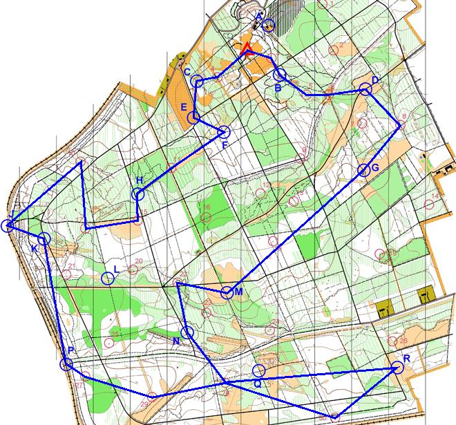
Map © Nottinghamshire Orienteering Club and reproduced with their permission. Survey: D & P Olivant September 2008 to February 2009. Cartography: D Olivant September 2008 to February 2009. Based on the Ordnance Survey mapping with the permission of the Controller of Her Majesty’s Stationery Office. © Crown Copyright. Licence No. 43423U. BOF Registration No. EM-08-456.