This table shows how many teams made it to each of the activities and control points.
|
Base
|
Description | Points | Number of visits |
|---|---|---|---|
| A | Bouncing Bombs (Small clearing.) | 50 | 67 |
| B | Big Bungee (Beside forest road.) | 50 | 51 |
| C | Child's Play (Playground south of forest road.) | 50 | 83 |
| D | Castle Siege (Forest clearing.) | 50 | 71 |
| E | Inflation (By track junction.) | 50 | 78 |
| F | Buzzin' (Woodland east of forest road.) | 50 | 71 |
| G | Goaaaaaaal! (Rough ground north of forest road.) | 50 | 79 |
| H | The Climb (Disused railway bridge.) | 50 | 62 |
| J | Caterpillar Tracks (Open ground by track crossroads.) | 50 | 66 |
| K | Wild West (East of forest road.) | 50 | 86 |
| L | Mud, Sweat and Gears (East of forest road.) | 50 | 78 |
| M | Bounce Back (Path junction.) | 50 | 66 |
N.B. There was no base I to avoid confusion with number 1.
| Control | Description | Points | Number of visits |
|---|---|---|---|
| 01 | Vehicle track, east side. | 10 | 0 |
| 02 | Path crossing. | 10 | 15 |
| 03 | Top of spider's web. | 5 | 59 |
| 04 | Small clearing, north side. | 5 | 43 |
| 05 | Small hill (knoll). | 10 | 30 |
| 06 | South of small pond. | 5 | 61 |
| 07 | On slope among trees. | 10 | 25 |
| 08 | Path junction, by marker post. | 15 | 30 |
| 09 | Road/path junction. | 10 | 48 |
| 10 | Clearing. | 20 | 12 |
| 11 | Vegetation boundary. | 10 | 53 |
| 12 | Small dip in ground (depression). | 15 | 6 |
| 13 | Gully. | 15 | 25 |
| 14 | North of footpath. | 20 | 11 |
| 15 | Small hill (knoll), south-west side. | 10 | 37 |
| 16 | Large dip in ground (depression). | 15 | 7 |
| 17 | Gully crossing. | 20 | 24 |
| 18 | Small hill (knoll). | 20 | 8 |
| 19 | Fence corner. | 20 | 17 |
| 20 | Small forest clearing. | 20 | 19 |
| 21 | By earthwall. | 15 | 22 |
| 22 | Small valley. | 15 | 40 |
| 23 | Alongside footpath. | 20 | 38 |
| 24 | Dip in ground (depression). | 20 | 20 |
| 25 | Small pit. | 25 | 11 |
| 26 | Fence corner. | 25 | 6 |
| 27 | Small dip in ground (depression). | 30 | 14 |
| 28 | Path junction. | 25 | 32 |
| 29 | Against fence. | 30 | 10 |
| 30 | Under pylon. | 30 | 24 |
| B1 | Tree, west of path. | 0 | 68 |
| B2 | Path junction. | 0 | 59 |
| X1 | -25 | 10 | |
| X2 | -25 | 5 | |
| X3 | -25 | 6 | |
| X4 | -25 | 12 |
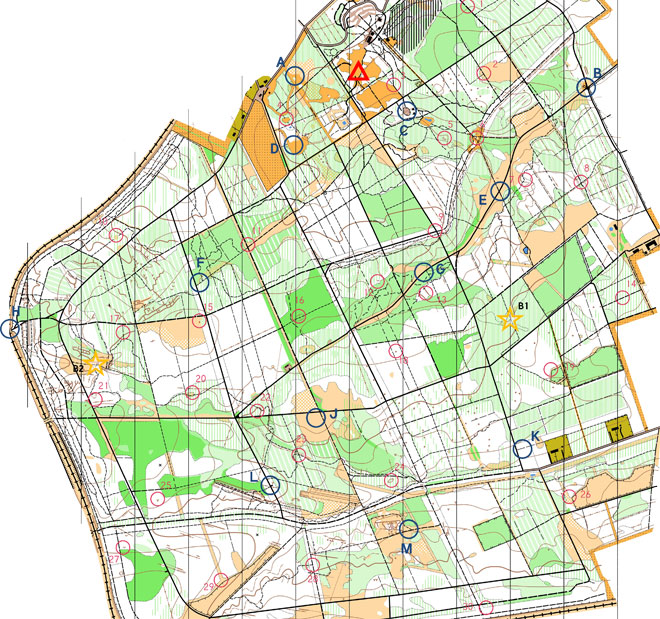
Map © Nottinghamshire Orienteering Club and reproduced with their permission. Survey: D & P Olivant September 2008 to February 2009. Cartography: D Olivant September 2008 to February 2009. Based on the Ordnance Survey mapping with the permission of the Controller of Her Majesty’s Stationery Office. © Crown Copyright. Licence No. 43423U. BOF Registration No. EM-08-456.