Snakes And Hatters
Atherstone District Explorers (Warwickshire)

| Start time |
End time |
Duration |
Distance |
Average speed |
| 19:05:00 |
01:03:51 |
05:58:51 |
9 km |
1 km/h |
| Control |
Description |
Time |
Points |
| 03 |
Top of spider?s web. |
19:17:22 |
5 |
| 05 |
Small hill (knoll). |
19:22:39 |
10 |
| 06 |
South of small pond. |
19:26:40 |
5 |
| 07 |
On slope among trees. |
19:34:40 |
10 |
| 08 |
Path junction, by marker post. |
19:41:33 |
15 |
| 14 |
North of footpath. |
19:54:43 |
20 |
| B1 |
Tree, west of path. |
20:07:35 |
0 |
| K |
Wild West (East of forest road. ) |
20:21:41 |
50 |
| M |
Bounce Back (Path junction. ) |
20:50:21 |
50 |
| 30 |
Under pylon. |
20:58:27 |
30 |
| L |
Mud, Sweat and Gears (East of forest road. ) |
22:02:51 |
50 |
| 23 |
Alongside footpath. |
22:16:26 |
20 |
| 18 |
Small hill (knoll). |
22:35:24 |
20 |
| G |
Goaaaaaaal! (Rough ground north of forest road. ) |
23:08:23 |
50 |
| 13 |
Gully. |
23:12:28 |
15 |
| 09 |
Road/path junction. |
23:27:32 |
10 |
| D |
Castle Seige! (Forest clearing. ) |
00:00:53 |
50 |
| A |
Bouncing Bombs (Small clearing. ) |
00:25:10 |
50 |
| C |
Child's Play (Playground south of forest road. ) |
00:57:04 |
50 |
| SUB-TOTAL |
610 |
| SUPER SCORE POINTS |
100 |
| TIME PENALTIES DEDUCTED |
0 |
| TOTAL |
610 |
Route map
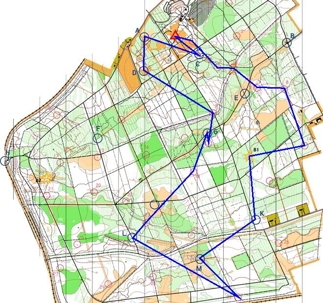
Map © Nottinghamshire
Orienteering Club and reproduced with their permission. Survey:
D & P Olivant September 2008 to February 2009. Cartography: D Olivant
September 2008 to February 2009. Based on the Ordnance Survey mapping
with the permission of the Controller of Her Majesty’s Stationery
Office. © Crown Copyright. Licence No. 43423U. BOF Registration
No. EM-08-456.
Back to main results table