The Exploraladoras
Berkswell Bears ESU (City of Coventry)

| Start time |
End time |
Duration |
Distance |
Average speed |
| 19:19:00 |
01:10:35 |
05:51:35 |
9 km |
1 km/h |
| Control |
Description |
Time |
Points |
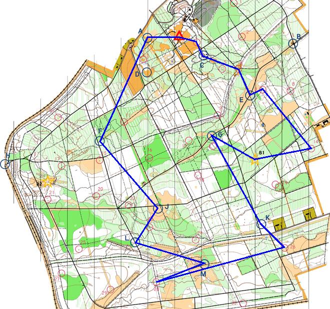
| 03 |
Top of spider?s web. |
19:22:22 |
5 |
| C |
Child's Play (Playground south of forest road. ) |
19:43:44 |
50 |
| 06 |
South of small pond. |
19:52:11 |
5 |
| E |
Inflation (By track junction. ) |
20:06:28 |
50 |
| 07 |
On slope among trees. |
20:13:34 |
10 |
| 14 |
North of footpath. |
20:40:35 |
20 |
| B1 |
Tree, west of path. |
20:49:50 |
0 |
| G |
Goaaaaaaal! (Rough ground north of forest road. ) |
21:20:37 |
50 |
| K |
Wild West (East of forest road. ) |
21:40:22 |
50 |
| 26 |
Fence corner. |
21:56:25 |
25 |
| 28 |
Path junction. |
22:30:08 |
25 |
| M |
Bounce Back (Path junction. ) |
23:21:05 |
50 |
| L |
Mud, Sweat and Gears (East of forest road. ) |
23:44:57 |
50 |
| J |
Caterpillar Tracks (Open ground by track crossroads. ) |
00:13:50 |
50 |
| F |
Buzzin' (Woodland east of forest road. ) |
00:36:19 |
50 |
| A |
Bouncing Bombs (Small clearing. ) |
01:02:50 |
50 |
| SUB-TOTAL |
640 |
| SUPER SCORE POINTS |
100 |
| TIME PENALTIES DEDUCTED |
0 |
| TOTAL |
640 |
Route map
Map © Nottinghamshire
Orienteering Club and reproduced with their permission. Survey:
D & P Olivant September 2008 to February 2009. Cartography: D Olivant
September 2008 to February 2009. Based on the Ordnance Survey mapping
with the permission of the Controller of Her Majesty’s Stationery
Office. © Crown Copyright. Licence No. 43423U. BOF Registration
No. EM-08-456.
Back to main results table