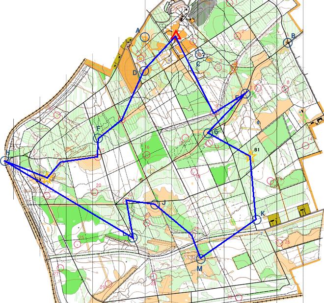
| D |
Castle Seige! (Forest clearing. ) |
20:32:03 |
50 |
| 11 |
Vegetation boundary. |
20:43:26 |
10 |
| F |
Buzzin' (Woodland east of forest road. ) |
20:54:10 |
50 |
| 15 |
Small hill (knoll), south-west side. |
21:00:22 |
10 |
| 17 |
Gully crossing. |
21:09:33 |
20 |
| B2 |
Path junction. |
21:14:56 |
0 |
| H |
The Climb (Disused railway bridge. ) |
21:29:22 |
50 |
| L |
Mud, Sweat and Gears (East of forest road. ) |
22:17:53 |
50 |
| 22 |
Small valley. |
22:41:52 |
15 |
| J |
Caterpillar Tracks (Open ground by track crossroads. ) |
23:10:35 |
50 |
| 24 |
Dip in ground (depression). |
23:30:18 |
20 |
| M |
Bounce Back (Path junction. ) |
00:32:32 |
50 |
| K |
Wild West (East of forest road. ) |
00:52:10 |
50 |
| B1 |
Tree, west of path. |
01:02:45 |
0 |
| G |
Goaaaaaaal! (Rough ground north of forest road. ) |
01:17:40 |
50 |
| E |
Inflation (By track junction. ) |
01:36:34 |
50 |
| 09 |
Road/path junction. |
01:45:49 |
10 |