The Tidybangers
Don ESU (South Yorkshire)

| Start time |
End time |
Duration |
Distance |
Average speed |
| 19:28:19 |
00:52:40 |
05:24:21 |
6 km |
1 km/h |
| Control |
Description |
Time |
Points |
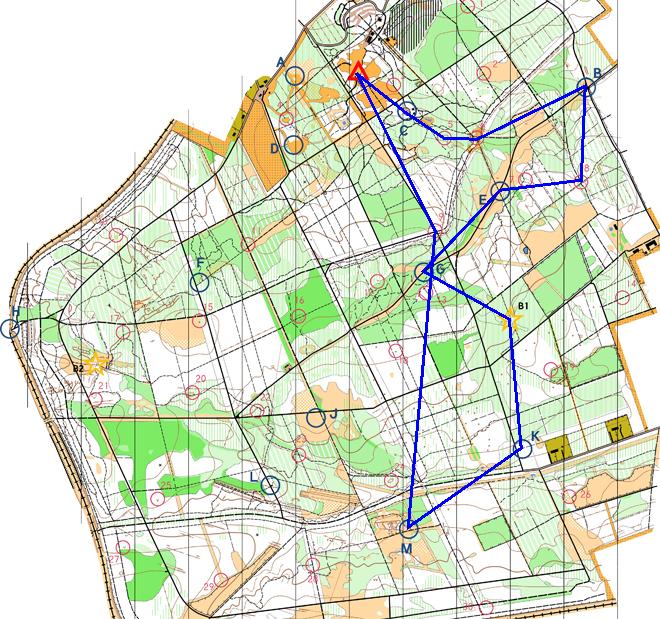
| C |
Child's Play (Playground south of forest road. ) |
19:58:11 |
50 |
| 05 |
Small hill (knoll). |
20:02:14 |
10 |
| 06 |
South of small pond. |
20:04:40 |
5 |
| B |
Big Bungee (Beside forest road. ) |
20:24:34 |
50 |
| 08 |
Path junction, by marker post. |
20:32:36 |
15 |
| E |
Inflation (By track junction. ) |
21:09:07 |
50 |
| G |
Goaaaaaaal! (Rough ground north of forest road. ) |
21:25:32 |
50 |
| B1 |
Tree, west of path. |
22:16:08 |
0 |
| K |
Wild West (East of forest road. ) |
22:38:58 |
50 |
| M |
Bounce Back (Path junction. ) |
23:56:22 |
50 |
| 09 |
Road/path junction. |
00:37:35 |
10 |
| SUB-TOTAL |
440 |
| SUPER SCORE POINTS |
100 |
| TIME PENALTIES DEDUCTED |
0 |
| TOTAL |
440 |
Route map
Map © Nottinghamshire
Orienteering Club and reproduced with their permission. Survey:
D & P Olivant September 2008 to February 2009. Cartography: D Olivant
September 2008 to February 2009. Based on the Ordnance Survey mapping
with the permission of the Controller of Her Majesty’s Stationery
Office. © Crown Copyright. Licence No. 43423U. BOF Registration
No. EM-08-456.
Back to main results table