#hikin4dayz
Hillsborough Explorers (South Yorkshire)

| Start time |
End time |
Duration |
Distance |
Average speed |
| 19:04:19 |
00:36:15 |
05:31:56 |
6 km |
1.1 km/h |
| Control |
Description |
Time |
Points |
| 06 |
Up tree |
19:09:09 |
5 |
| D |
Cave On The Go (Double gates) |
19:18:43 |
50 |
| 12 |
Wooden fence corner |
19:33:29 |
5 |
| F |
On Target (Field corner) |
19:35:31 |
50 |
| 17 |
Dip in ground |
19:41:14 |
10 |
| J |
Popstars (Disused water tower) |
19:46:24 |
50 |
| 21 |
Pond, south side |
19:51:32 |
15 |
| M |
UXB (Edge of field) |
20:12:25 |
50 |
| 28 |
Spring |
20:19:40 |
30 |
| 25 |
Stream junction |
20:28:44 |
25 |
| 27 |
Watery hole in the wall |
20:43:22 |
20 |
| K |
Commercial Break (Roundhouse) |
20:54:09 |
50 |
| 23 |
Obelisk, west side |
20:56:36 |
15 |
| P |
Temple Of Doom (Mysterious temple) |
21:24:47 |
50 |
| 26 |
Brick foundations |
21:50:10 |
30 |
| 30 |
Under pylon, east side |
21:57:11 |
30 |
| 29 |
Under pylon, south side |
22:03:51 |
25 |
| 22 |
Brick foundations |
22:14:44 |
25 |
| B2 |
Bonus control 2 |
22:23:13 |
0 |
| H |
Bullseye! (Woodland track) |
22:39:24 |
50 |
| L |
Keeping a Log (Track over stream) |
22:51:10 |
50 |
| 18 |
Pond |
23:01:25 |
30 |
| 11 |
Exposed tree roots |
23:33:55 |
20 |
| B1 |
Bonus control 1 |
23:47:34 |
0 |
| C |
On The Ropes (Old quarry) |
00:12:49 |
50 |
| A |
Chickin Lickin' (Most easterly pond) |
00:26:15 |
50 |
| SUB-TOTAL |
785 |
| SUPER SCORE POINTS |
200 |
| TIME PENALTIES DEDUCTED |
0 |
| TOTAL |
985 |
Route map
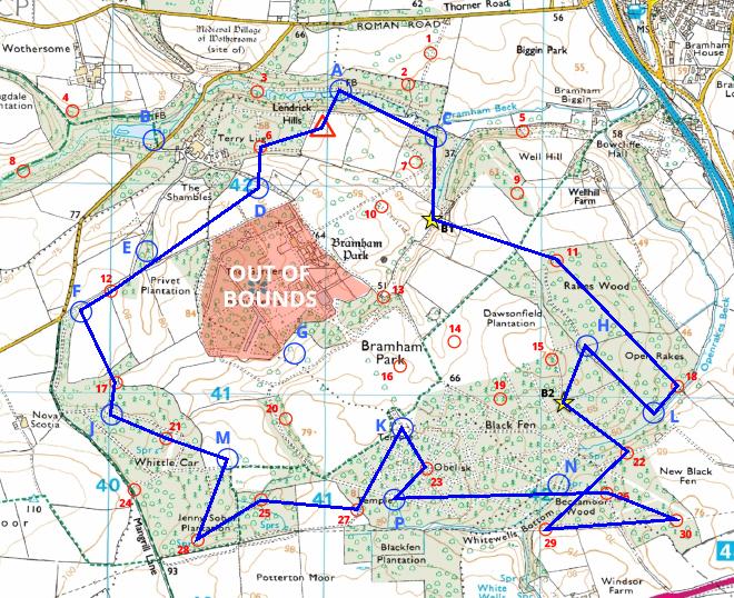
Map reproduced from Ordnance Survey mapping with their permission, on behalf of the controller of Her Majesty's Stationery Office.
Back to main results table