Cuthbert's Destroyers
St. Cuthbert's (Humberside)

| Start time |
End time |
Duration |
Distance |
Average speed |
| 18:53:54 |
00:15:59 |
05:22:05 |
5 km |
0.9 km/h |
| Control |
Description |
Time |
Points |
| 06 |
Up tree |
19:00:00 |
5 |
| 03 |
Log over stream |
19:08:13 |
10 |
| A |
Chickin Lickin' (Most easterly pond) |
19:36:50 |
50 |
| 02 |
Fence corner |
19:42:34 |
10 |
| 01 |
Group of trees |
19:45:23 |
15 |
| 07 |
Charred tree stump |
19:52:49 |
5 |
| 10 |
Up tree |
20:06:54 |
5 |
| B1 |
Bonus control 1 |
20:11:03 |
0 |
| 11 |
Exposed tree roots |
20:39:33 |
20 |
| H |
Bullseye! (Woodland track) |
20:55:22 |
50 |
| L |
Keeping a Log (Track over stream) |
21:15:00 |
50 |
| 18 |
Pond |
21:24:45 |
30 |
| 15 |
Ruined building |
21:42:08 |
15 |
| B2 |
Bonus control 2 |
21:46:21 |
0 |
| N |
Flag Pipes (Track over stream) |
22:09:28 |
50 |
| 26 |
Brick foundations |
22:15:33 |
30 |
| 22 |
Brick foundations |
22:19:41 |
25 |
| 30 |
Under pylon, east side |
22:31:27 |
30 |
| 29 |
Under pylon, south side |
22:42:17 |
25 |
| 23 |
Obelisk, west side |
22:52:51 |
15 |
| G |
Supersledge (Grassy slope) |
23:41:09 |
50 |
| SUB-TOTAL |
490 |
| SUPER SCORE POINTS |
150 |
| TIME PENALTIES DEDUCTED |
0 |
| TOTAL |
640 |
Route map
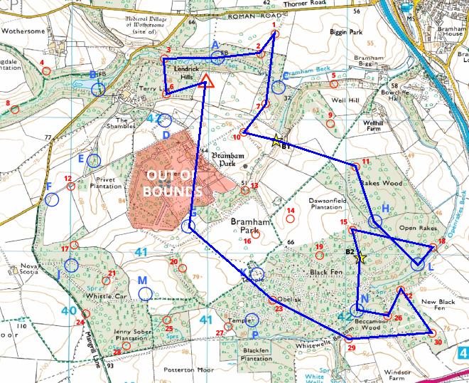
Map reproduced from Ordnance Survey mapping with their permission, on behalf of the controller of Her Majesty's Stationery Office.
Back to main results table