Haaave You Met Martha?
Ayers Explorer Scout Unit (Cumbria)
| Start time |
End time |
Duration |
Distance |
Average speed |
| 18:59:24 |
00:58:37 |
05:59:13 |
7 km |
1.1 km/h |
| Control |
Description |
Time |
Points |
| 06 |
Up tree |
19:04:56 |
5 |
| D |
Cave On The Go (Double gates) |
19:16:54 |
50 |
| 08 |
Stream bend |
19:38:41 |
25 |
| 04 |
Below rocky outcrop |
19:43:45 |
10 |
| B |
Dark Water (Lake) |
20:04:32 |
50 |
| 12 |
Wooden fence corner |
20:19:26 |
5 |
| F |
On Target (Field corner) |
20:22:05 |
50 |
| J |
Popstars (Disused water tower) |
20:35:14 |
50 |
| 17 |
Dip in ground |
20:37:50 |
10 |
| 21 |
Pond, south side |
20:46:31 |
15 |
| 24 |
Large trees by gate |
20:56:55 |
25 |
| 28 |
Spring |
21:04:33 |
30 |
| M |
UXB (Edge of field) |
21:29:38 |
50 |
| 20 |
Largest tree |
21:40:31 |
15 |
| G |
Supersledge (Grassy slope) |
21:55:24 |
50 |
| 13 |
Under bridge |
22:09:50 |
10 |
| 16 |
Tree |
22:21:00 |
10 |
| K |
Commercial Break (Roundhouse) |
22:42:49 |
50 |
| 23 |
Obelisk, west side |
22:48:06 |
15 |
| 27 |
Watery hole in the wall |
22:59:02 |
20 |
| N |
Flag Pipes (Track over stream) |
23:28:57 |
50 |
| 26 |
Brick foundations |
23:37:18 |
30 |
| 29 |
Under pylon, south side |
23:45:18 |
25 |
| 30 |
Under pylon, east side |
23:53:59 |
30 |
| 22 |
Brick foundations |
00:12:33 |
25 |
| L |
Keeping a Log (Track over stream) |
00:24:50 |
50 |
| 11 |
Exposed tree roots |
00:37:30 |
20 |
| SUB-TOTAL |
775 |
| SUPER SCORE POINTS |
0 |
| TIME PENALTIES DEDUCTED |
0 |
| TOTAL |
775 |
Route map
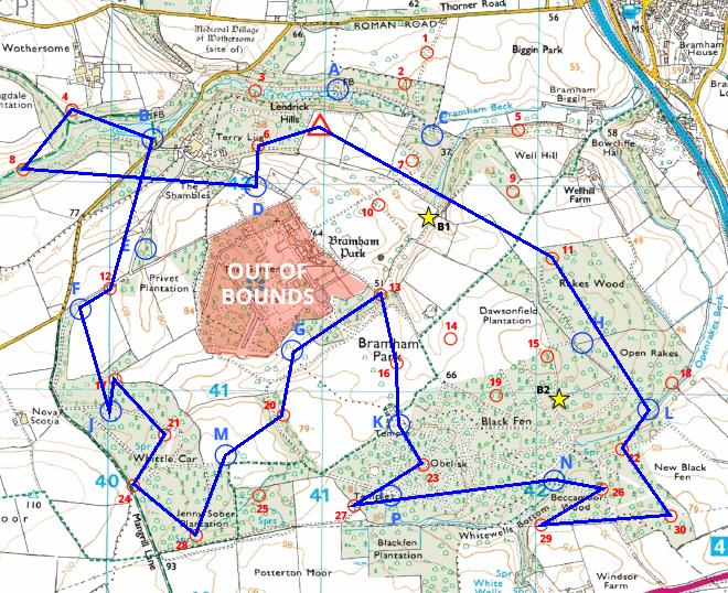
Map reproduced from Ordnance Survey mapping with their permission, on behalf of the controller of Her Majesty's Stationery Office.
Back to main results table