Otley Mad Cow Too
Otley Mad Cow Explorers (West Yorkshire)

| Start time |
End time |
Duration |
Distance |
Average speed |
| 20:04:21 |
02:00:17 |
05:55:56 |
5 km |
0.9 km/h |
| Control |
Description |
Time |
Points |
| B1 |
Bonus control 1 |
20:16:16 |
0 |
| 11 |
Exposed tree roots |
20:27:10 |
20 |
| H |
Bullseye! (Woodland track) |
20:41:53 |
50 |
| 15 |
Ruined building |
20:48:08 |
15 |
| B2 |
Bonus control 2 |
20:56:36 |
0 |
| L |
Keeping a Log (Track over stream) |
21:15:13 |
50 |
| N |
Flag Pipes (Track over stream) |
21:43:02 |
50 |
| 26 |
Brick foundations |
21:50:24 |
30 |
| 29 |
Under pylon, south side |
22:23:04 |
25 |
| 23 |
Obelisk, west side |
22:32:12 |
15 |
| K |
Commercial Break (Roundhouse) |
23:00:20 |
50 |
| 27 |
Watery hole in the wall |
23:15:33 |
20 |
| 25 |
Stream junction |
23:33:06 |
25 |
| M |
UXB (Edge of field) |
00:02:03 |
50 |
| 24 |
Large trees by gate |
00:08:31 |
25 |
| 21 |
Pond, south side |
00:16:03 |
15 |
| J |
Popstars (Disused water tower) |
00:23:11 |
50 |
| 17 |
Dip in ground |
00:25:44 |
10 |
| F |
On Target (Field corner) |
00:36:35 |
50 |
| 12 |
Wooden fence corner |
00:39:02 |
5 |
| E |
Woodland Wonder (Small plantation) |
01:09:40 |
50 |
| D |
Cave On The Go (Double gates) |
01:27:55 |
50 |
| A |
Chickin Lickin' (Most easterly pond) |
01:53:33 |
50 |
| SUB-TOTAL |
705 |
| SUPER SCORE POINTS |
170 |
| TIME PENALTIES DEDUCTED |
0 |
| TOTAL |
875 |
Route map
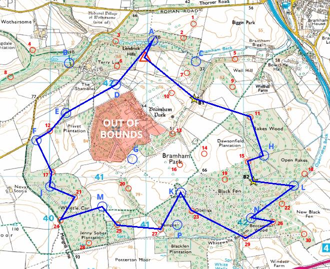
Map reproduced from Ordnance Survey mapping with their permission, on behalf of the controller of Her Majesty's Stationery Office.
Back to main results table