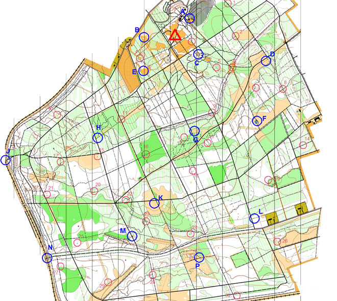
This table shows how many teams made it to each of the activity bases and other controls.
Base |
Description | Points |
Number of visits |
|---|---|---|---|
| A | Dirty Bombs (Large classroom near Go Ape.) | 50 | 43 |
| B | In a Spin (Small clearing.) | 50 | 67 |
| C | On the Ropes (Playground South of forest road.) | 50 | 75 |
| D | On Target (Open space area by forest road.) | 50 | 65 |
| E | Mega Assault (Large clearing.) | 50 | 83 |
| F | Powerboats (Pond.) | 50 | 56 |
| G | Free For All! (Clearing East of vehicle track.) | 50 | 46 |
| H | Go Apex(x) (Woodland East of forest road.) | 50 | 54 |
| J | The Climb (Disused railway bridge.) | 50 | 55 |
| K | Bouncy Coconuts (South West of track junction.) | 50 | 63 |
| L | Giant Jenga (East of forest road.) | 50 | 57 |
| M | Blood, Sweat and Gears (East of forest road.) | 50 | 68 |
| N | Go Ballistic (Derelict railway bridge.) | 50 | 19 |
| P | Down the Drain (Track junction.) | 50 | 45 |
N.B. There was no base I to avoid confusion with number 1 or base O to avoid confusion with letter D.
| Control | Description | Points |
Number of visits |
|---|---|---|---|
| 01 | Vehicle track - East side. | 10 | 0 |
| 02 | Path crossing. | 10 | 13 |
| 03 | Top of spiders? web. | 5 | 41 |
| 04 | Small clearing - North side. | 5 | 31 |
| 05 | Small hill (knoll). | 10 | 8 |
| 06 | South of small pond. | 5 | 34 |
| 07 | On slope among trees. | 10 | 0 |
| 08 | Path junction, by marker post. | 15 | 28 |
| 09 | Road / path junction. | 10 | 36 |
| 10 | Clearing. | 20 | 11 |
| 11 | Vegetation boundary. | 10 | 33 |
| 12 | Small dip in ground (depression). | 15 | 8 |
| 13 | Gully. | 15 | 3 |
| 14 | North of footpath. | 20 | 13 |
| 15 | Small hill (knoll) - South-West side. | 10 | 46 |
| 16 | Large dip in ground (depression). | 15 | 5 |
| 17 | Gully crossing. | 20 | 19 |
| 18 | Small hill (knoll). | 20 | 4 |
| 19 | Fence corner. | 20 | 20 |
| 20 | Small forest clearing. | 20 | 6 |
| 21 | By earthwall. | 15 | 13 |
| 22 | Small valley. | 15 | 24 |
| 23 | Alongside footpath. | 20 | 25 |
| 24 | Dip in ground (depression). | 20 | 12 |
| 25 | Small pit. | 25 | 9 |
| 26 | Fence corner. | 25 | 21 |
| 27 | Small dip in ground (depression). | 30 | 23 |
| 28 | Path junction. | 25 | 10 |
| 29 | Against fence. | 30 | 11 |
| 30 | Under pylon. | 30 | 15 |
Map © Nottinghamshire Orienteering Club and reproduced with their permission. Survey: D & P Olivant September 2008 to February 2009. Cartography: D Olivant September 2008 to February 2009. Based on the Ordnance Survey mapping with the permission of the Controller of Her Majesty’s Stationery Office. © Crown Copyright. Licence No. 43423U. BOF Registration No. EM-08-456.